Sunday, November 18, 2007
Sunday, November 11, 2007
Scout Lake, 11-11-07

I'd heard that the weather in the mountains wouldn't be too bad (always a subjective notion), so off I went with a neighbor to see if the big storms last year had obliterated the road to the Scout Lake trailhead. The old logging road was potholed enough, but entirely driveable.
There is a very underused road partway up the main logging road, and that's where we began our hike. The weather was very grey, but the snow line was very clear and we were going to go above it. We loaded up on the usual extra clothing, food, H2O, gloves, and hats. And did we ever need them when we got to the lake at 3900' and the wind came down the side of the cirque and across the water! It must have easily been in the 20s with the windchill.
Talus covered much of this side of the lake. Lots of avalanche potential when heavy snow. And of course I'm standing on the icy, snowy rocks at the base of that talus in the bottom picture.

 The path parallels Hansen Creek and one would think that you could just walk along the banks, but no, there are some nice 10 - 20' dropoffs with waterfalls, tons of fallen trees and defoliated Devil's club (thorns wholely intact). Redtwig dogwood, brilliant green ferns, golden orange chantarelle mushrooms, and dark, dark green conifers made up most of the landscape until we got into the snow, and it all became the dark green equivalent of sepia and white. I imagine in a few weeks there will be at least a foot or two of snow, and white and the dark brown of any exposed trunks will dominate the visual field.
But the few inches of sticking snow that we walked through was plenty cold and Scout Lake was starting to freeze over with a slushy layer that rippled in places according to whatever was underneath it. A waterbug skimmed the surface and I can't imagine that it had much of a protective fat layer to hold it over the winter. The reflected trees and rocks on the glassy surface resembled a Fair Isle sweater pattern.
The hike up was 1 1/2 hours, only 1 hour down - pretty slippery mud along the way and several blowdowns to climb over. Oh, yes, and there was that 30' traverse over the creek balancing on 2 large trees...
 Coming down the road we had a clear view of the Granite Mt. lookout across I-90. A dusting of snow covered its bald top and I'm sure the wind coming down the I-90 valley kept it even colder than where we had been!
Saturday, October 27, 2007
Mt. Washington (Cascades) 10-27-07
 Fog towards the west
 Ice
Ice First snow and snowball of the season!
Saturday, September 29, 2007
Cartoons about the great outdoors
Saturday, September 8, 2007
Mt. Rainier National Park - Skyline Loop, 9-8-07


 Looking south along Nisqually Valley
 Mt. St. Helens
 Mt. Adams
Just a few of the wildflowers were blooming or showing off their amazing seedpods - magenta and orange Indian paintbrush, windflower (a type of anemone) with its windblown beehive hairstyle strands of seeds, deep blue gentium, lavender asters. The trees were green, green, green, and the huckleberries once again were seriously depleted after our group grazed through.


Geologic note from the happy academic geologist - the Cascade volcanoes were formed from very violent and explosive eruptions. This is because of the high levels of
 quartz, feldspar, and other minerals in the lava that would essentially clog the "veins" where magma collected, thus causing an incredible amount of pressure to build up until the eruption. Granitic magma. Rhyolite, pumice, and granite were all obvious by-products of long-ago eruptions. The last eruption of Rainier was around 150 years ago and by all prediction we are due for another major one. However, we felt no rumblings on this outing!

 And here are more cool rocks and landscapes -
Approaching the part that resembled Mars


Happy academic geologist pointing out where a glacier probably smoothed one surface of this rock.
We felt like there should have been a glacier here; probably had been one here fairly recently because the soil in the area did not have much green in it. The going thought was that nitrogen had not had time to fix in that area, so, no plants to take in the nitrogen.
This hike was just a tiny fraction of the amazing sights around this mountain, so hopefully I'll have more opportunities to explore it more.
Saturday, August 25, 2007
Mt. Dickerman - 8-25-07

Tuesday, August 7, 2007
föstudagur, 27 júlí
 Sun Voyager
Þjóðminjasafn Íslands - National Museum of Iceland
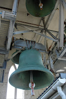
Very large bell - 4'+ high - in Hallgrímskirkja
Typical house with bright colors and flower boxes
Looking out from top of Hallgrímskirkja - NW
Looking NE...
SW
Modern wear and weaponry for children
Assorted dyed reindeer hides and sealskin
These are bagels?!!!
BSÍ - central bus station
Last sunset in Reykjavík
Bless!


